Here it is:
http://picasaweb.google.com/grulifson/PadangSummer2010?feat=directlink
In case you want to see more of what we did and what life was like in Padang through the majesty of photo and short videos (and there are captions on many of them).
Thanks for reading!
-Lucy dan Greg
Friday, October 1, 2010
Wednesday, August 25, 2010
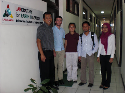
Soil Investigations: August 4-14, 2010
As part of site selections for TEREP, we did some preliminary soil investigations on three sites. Since hiring a geotech company to come out and do these investigations would cost a lot of time and money, we did them ourselves, with equipment from Andalas and UNP.
August 4, 2010 – UNP
UNP (Padang State University) is one of the most promising sites for the TEREP project so far. So we borrowed a hand auger and a lab technician from Andalas University to go do the investigations. But Andalas is really far and the equipment is heavy. We really needed either a car or at least two motorbikes. We had a car for the morning and only one motorbike for the rest of the time.
There were only three of us but the lab technician really knew what he was doing so we started pretty fast after we got to the site. But less than a meter into the ground, we hit a lot of gravel. The hand auger cannot penetrate the layer of rocks. We were then told that most of the university sits on a layer of fill about a meter deep. We had only hoped to go down about 2 meters deep in the first place. We poked around some more after lunch but got no success. I took a sample of the fill and we're hoping do grain size analysis on all the samples very soon.
August 5, 2010 – Seismic CPT
We had heard from Adrin Tohari at LIPI that UNP has a Seismic CPT machine at their campus. This CPT machine looks like all the other ones in this region. It is a Sondir-type machine that has a hydraulic (I think) motor attached to it. There is no truck involved. The reaction for the machine seems to be just the motor. The special thing about this machine is that it has the capability of doing seismic wave tests.
We were able to verify its existance. But it is currently sitting in storage at UNP because no one knows how to use it. It's such a shame because it is probably the only machines in all of Sumatra that can do both CPT and seismic waves. I contacted the company (Geomil) in the Netherlands and they sent me some instructions. The representative said that the machine is very similar to other Sondir machines so that someone experienced with those machines can operate this one with no problems. They also gave me a contact for a company in Singapore. It would be nice to get this machine up before we leave.
We also got permission to borrow (rent) UNP's hand auger for more soil exploration. The equipment at Andalas turned out to be unavailable and really far from where we want to do investigations. So we managed to borrow the equipment along with three undergraduate students and two motorbikes for the next two days.
August 6, 2010 – Terminal Lubuk Buaya
This site is a very swampy field with some overgrown vegetation and lots of children running around. The watertable is very high, at around 40cm from the surface. Because we did not have a GPS or surveying equipment, we paced out the field using the neighborhood houses as our references.
August 7, 2010 – Basko River Site
This is the site that the ESW Spring 2010 TEREP Design Team (aka Lil Bermie) did the conceptual design project on. This site is across the river from the Basko Hotel, a major landmark in the city.
The investigations went a lot more smoothly because everyone knew what they were doing. We hit a lot of obstructions, mostly large gravel. We managed to finish by lunchtime. We went out to lunch together afterwards. The short day and food was much appreciated by everyone since it was Saturday!
August 13 and 14, 2010 – Grain Size Analysis at Andalas
We collected 13 soil samples total. We dried them in the tiny oven in the soils labortaory at Andalas. This lab seems to be heavily used by students working on projects even though it is summer vacation. After drying, we put them through a sieve shaker and weighed each sieve to determine the grading of each sample.
The Report
I have organized my notes into a report on this preliminary site investigation. This can be found here:
http://www.stanford.edu/~lucywu/TEREP/PDFs/
Tuesday, August 17, 2010
Rendang Express
When you get on a flight from Jakarta to Padang, everyone is bringing back at least three boxes of donuts. Duncan Donuts is a favorite. So what do you bring when you fly from Padang to Jakarta? Rendang, of course. For those of you who don't know, rendang is beef cooked in coconut milk and other spices for hours and eaten with rice. So what if you have friends and relatives who live really far away, craving for your home cooked rendang? Cook up a huge pot and mail it!
We saw this poster at the main post office. How to properly package rendang for shipping. Don't get your hopes up though, we're still working on Step 1.


We saw this poster at the main post office. How to properly package rendang for shipping. Don't get your hopes up though, we're still working on Step 1.

Saturday, August 14, 2010
Bandung
--- August 1 -3, 2010---
Getting to and around Bandung
Sunday, August 1, 2010. Another 6am flight to Jakarta! This time, we did not leave the airport and got on a shuttle bus to Bandung. We had to wait an hour and a half after we got to the airport though because these minibuses get full very quickly. Lesson learned, book the shuttle while waiting for your luggage. Better yet, don't check in anything because it takes forever. Lion Air from Padang flies into the international terminal and then you take a shuttle to the domestic arrivals. Your luggage takes a long time to get to the domestic terminal because they can't move themselves.
The bus from Jakarta airport to Bandung takes about three hours. We wandered around Bandung for most of Sunday afternoon, hoping on and off angkots. The angkots in Bandung cost only 1500 Rp and does not offer loud music. It felt strange to be sitting in an angkot with no music and stuffed animals.
One of the surprising things about Bandung is the weather. It was not hot and humid like Padang. It is at higher altitude and has more Bay Area like weather. Greg and I enjoyed this a lot. The chilis for food also comes on the side. And after eating Padang food for a month, Bandung food is definitely not spicy.
Meeting with Adrin Tohari at LIPI
The second day (Monday) in Bandung started off with us walking over to LIPI, a science research center. We talked to a getoech researcher, Adrin Tohari, about his liquefaction research in Padang. He had really great information and was willing to share with us. I think he was excited that someone was interested in his work. He had done field studies in Padang in 2006 and 2008 (right before the big earthquakes in 2007 and 2009). The earthquakes verified his field studies.
I've been looking for soil data for this city for ages. It seems like various people and agencies have done their own studies but haven't shared them with anyone. I would like to make a database and share the information online somehow. In the US, we spend quite a bit of time finding “historical” geology and geotechnical information for a site before going out to do our own site investigations. Knowing the previous use of the site can help a lot as well. It's really difficult to collect such information here unless you're running around gathering these things by angkot!
Meeting with Professor Wayan Sengara at ITB
That afternoon, we had a meeting with Wayan Sengara, a geotech professor at ITB. We told him about our project and he gave us some references. He has a poster outside his office about soil studies that he has done in Padang. But he was not as willing to share the data because they belong to his students. He pointed us back to Andalas for more data, saying that Professor Hakam has the most complete soil data for the Padang area.
Anggun, one of his students, asked him about the possibility of doing her Master's thesis on the TEREP project. Right now, she is thinking about looking into the impact of tsunami forces on the soil berm. He was supportive of this idea. We suggested that his other students who are looking for a thesis topic can work on our project since there are many potential topics available. He seemed interested in having a collaboration between ITB, Stanford, and Andalas.
Other Bandung Adventures
Andi and Greg left for Jakarta for the HAKI conference after the meeting with Pak Wayan. Tuesday morning was a busy one for me. I went with Anggun to a little copy place on the ITB campus where the guy makes copies of textbooks and sells them for a quarter of the price. Textbooks here are much cheaper to begin with, about $20 a book. So this place basically sells textbooks for about $5 each. He even binds them so that they look like actual books. The only difference is that all the images are in black and white instead of color. I picked out several titles and he found one of them. So I got a book on soil improvement for about $4.
After this, we went over to the geology museum. It's a really nice museum since Indonesia has all the goelogical features you would ever want to see. We spent a lot of time hunting down a geology map for Padang though so we didn't get to walk through the exhibits. We found a pretty recent 1:250,000 geology map and paid 100,000 Rp for it. A bit expensive but I thought it was better than having to go back to Bandung for it if it turns out to be useful.
I flew Batavia Airlines back to Padang. Batavia flies out of Terminal B instead of A. Batavia is much nicer than Lion Air. The seats were more comfortable and they handed out water and bread.
Getting to and around Bandung
Sunday, August 1, 2010. Another 6am flight to Jakarta! This time, we did not leave the airport and got on a shuttle bus to Bandung. We had to wait an hour and a half after we got to the airport though because these minibuses get full very quickly. Lesson learned, book the shuttle while waiting for your luggage. Better yet, don't check in anything because it takes forever. Lion Air from Padang flies into the international terminal and then you take a shuttle to the domestic arrivals. Your luggage takes a long time to get to the domestic terminal because they can't move themselves.
The bus from Jakarta airport to Bandung takes about three hours. We wandered around Bandung for most of Sunday afternoon, hoping on and off angkots. The angkots in Bandung cost only 1500 Rp and does not offer loud music. It felt strange to be sitting in an angkot with no music and stuffed animals.
 |
| From Padang Summer 2010 |
One of the surprising things about Bandung is the weather. It was not hot and humid like Padang. It is at higher altitude and has more Bay Area like weather. Greg and I enjoyed this a lot. The chilis for food also comes on the side. And after eating Padang food for a month, Bandung food is definitely not spicy.
Meeting with Adrin Tohari at LIPI
The second day (Monday) in Bandung started off with us walking over to LIPI, a science research center. We talked to a getoech researcher, Adrin Tohari, about his liquefaction research in Padang. He had really great information and was willing to share with us. I think he was excited that someone was interested in his work. He had done field studies in Padang in 2006 and 2008 (right before the big earthquakes in 2007 and 2009). The earthquakes verified his field studies.
 |
| From Padang Summer 2010 |
I've been looking for soil data for this city for ages. It seems like various people and agencies have done their own studies but haven't shared them with anyone. I would like to make a database and share the information online somehow. In the US, we spend quite a bit of time finding “historical” geology and geotechnical information for a site before going out to do our own site investigations. Knowing the previous use of the site can help a lot as well. It's really difficult to collect such information here unless you're running around gathering these things by angkot!
Meeting with Professor Wayan Sengara at ITB
That afternoon, we had a meeting with Wayan Sengara, a geotech professor at ITB. We told him about our project and he gave us some references. He has a poster outside his office about soil studies that he has done in Padang. But he was not as willing to share the data because they belong to his students. He pointed us back to Andalas for more data, saying that Professor Hakam has the most complete soil data for the Padang area.
Anggun, one of his students, asked him about the possibility of doing her Master's thesis on the TEREP project. Right now, she is thinking about looking into the impact of tsunami forces on the soil berm. He was supportive of this idea. We suggested that his other students who are looking for a thesis topic can work on our project since there are many potential topics available. He seemed interested in having a collaboration between ITB, Stanford, and Andalas.
 |
| From Padang Summer 2010 |
Other Bandung Adventures
Andi and Greg left for Jakarta for the HAKI conference after the meeting with Pak Wayan. Tuesday morning was a busy one for me. I went with Anggun to a little copy place on the ITB campus where the guy makes copies of textbooks and sells them for a quarter of the price. Textbooks here are much cheaper to begin with, about $20 a book. So this place basically sells textbooks for about $5 each. He even binds them so that they look like actual books. The only difference is that all the images are in black and white instead of color. I picked out several titles and he found one of them. So I got a book on soil improvement for about $4.
After this, we went over to the geology museum. It's a really nice museum since Indonesia has all the goelogical features you would ever want to see. We spent a lot of time hunting down a geology map for Padang though so we didn't get to walk through the exhibits. We found a pretty recent 1:250,000 geology map and paid 100,000 Rp for it. A bit expensive but I thought it was better than having to go back to Bandung for it if it turns out to be useful.
I flew Batavia Airlines back to Padang. Batavia flies out of Terminal B instead of A. Batavia is much nicer than Lion Air. The seats were more comfortable and they handed out water and bread.
Wednesday, August 11, 2010
Preliminary Mosque Survey
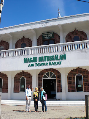
One of the main objectives of this internship, following the work done in the class last Spring, is to investigate a number of mosques for their adequacy as vertical evacuation structures. As you can see in the booklet (link) created by the retrofit team, mosques are great options for evacuation, but they are certainly not guaranteed to be safe during the earthquake and tsunami without further investigation and possibly retrofit, both structural and non-structural.
The first step was to identify about 10 mosques from Google Earth that looked decent for evacuation based on their distance from the coast, the flow depth at the site based on the Last Mile inundation map (link), the population density in the region, and Andi’s knowledge of the mosque’s height, quality, and any other useful information (the benefits of working with a local). After compiling this information during a long afternoon in the Construction Clinic, we chose 8 mosques to visit.
One of the students who finished undergraduate study in Civil Engineering at Andalas University, and now attends Bandung Institute of Technology, Anggun, was able to accompany Andi, Lucy and I in the investigation. We drove (yes, not angkots this time) to four mosques in one afternoon to speak with many of the mosque managers and briefly survey the size and height of the mosque that seemed plausible from our Google viewing. Four days later, we went to three more mosques somewhat near the coast to accomplish the same tasks. We even stopped by an extra one because we ran into it on the way (shows the proliferation of mosques in the city).
Through our investigation (see some photos here, here, and here), we were able to identify 3 mosques that we will investigate further to be used as vertical evacuation structures based on their size and height. We will need to dig deeper in order to find out how much steel is in the members and the quality of the concrete to make our own structural drawings for analysis. Also, most need better access, especially to the roof, in order to be plausible and that is something we will discuss with the owners and mosque managers when we return.
We plan to analyze two mosques while still in Padang with the Andalas students, or at least get the process well-started so they can continue for their class in September and proceed with more mosques that we investigate. This can be a relatively quick, effective, and economical way to prepare some of the communities in Padang, and with more involvement, it can become scalable as well.
TEPO – Tsunami Evacuation Pedestrian Overpass
Thursday, July 22, 2010
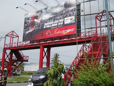
One of the ideas for the next design class is looking into using pedestrian overpasses as evacuation structures. Pedestrian overpasses are very common in Indonesia in general and the ones in Padang performed well in the last earthquake. So we set out to do an initial assessment of the two that are currently in Padang.
Tabing. There is one located in Tabing, right next to the train station. This one used to be outside of Basko Hotel but got moved to Tabing, probably because the government thought it would be used more. This one is made with steel.
Some concerns we have about this one:
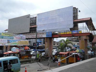
Andalas Plaza. The other one is located outside of Andalas Plaza. The stesp on the mall side of this one is heavily used by people hanging out. When we got there, a bunch of teenage girls were chatting on the steps. There is overhead covering for the stairs and bridge. This one has concrete supports and a metal deck.
Comments about TEPO idea in general:
Everyday useage will be a big issue. If people don't use it regularly, then they will not think of using it during an emergency. Right now it is easier to walk across the street between traffic than to climb one of these things. The stairs are very steep (around 45 degrees?) and takes a lot of energy to get up. Perhaps escalators will help but they use electricity. At the Tabing overpass, we saw circuit boxes but they were empty.
Maintenance is another issue. In theory, the overpasses can hold a lot of people but the quality of the floor panels are questionable. It seems dangerous to pack a lot of people onto the structure and risk breaking the floor panels.
Capacity is an issue that was brought up at a KOGAMI meeting. They do not hold very much people and are not fully enclosed structure (like the inside of a building). So there is concern of people falling when more and more people try to cram into the space. But perhaps this issue can be solved by having bigger overpasses that straddle an entire intersection and having enough of them.
Not sure what the final solution for the TEPO idea will look like. A feasibility study will definitely be needed before the design of one. Perhaps a comparative study with another city where overpasses are heavily used and well maintained should be done. This could turn out to be a very interesting design project though.
At the time of this writing, we have not managed to get drawings from DTRTB.
One of the ideas for the next design class is looking into using pedestrian overpasses as evacuation structures. Pedestrian overpasses are very common in Indonesia in general and the ones in Padang performed well in the last earthquake. So we set out to do an initial assessment of the two that are currently in Padang.
 |
| From Padang Summer 2010 |
Tabing. There is one located in Tabing, right next to the train station. This one used to be outside of Basko Hotel but got moved to Tabing, probably because the government thought it would be used more. This one is made with steel.
Some concerns we have about this one:
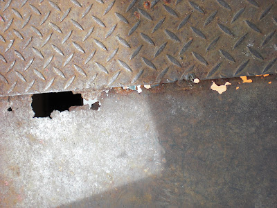
- Floor panels – They were very thin and rusted. Maintenance is an issue.
From Padang Summer 2010 - Connections to the ground – How deep do the bolts go? Are they bolted only to the concrete block?
- Usage – There are discarded cigaretts and graffti, therefore some people use it as a hangout.
- Dimensions:
- 24.24 m long (across the street)
- 2.20 m wide
- 6.3 m high (ground to deck)
- 2 m wide access (entrance)
 |
| From Padang Summer 2010 |
Andalas Plaza. The other one is located outside of Andalas Plaza. The stesp on the mall side of this one is heavily used by people hanging out. When we got there, a bunch of teenage girls were chatting on the steps. There is overhead covering for the stairs and bridge. This one has concrete supports and a metal deck.
- Stairs – Support for stairs looks thin: buckling issues. Flange for the column is only 6” wide. Some bolts are missing.
- Connection to the ground – Not sure how deep the concrete extends below ground.
- Connection to deck – Cannot see how the metal deck is connected with the concrete columns.
- Floor panels – Lots of rusted pieces everywhere. Pools of water. Floor has been patched with different panels. Very thin.
- Dimensions:
- 29 m long (across the street)
- 1.3 m wide
- 6 m high (ground to deck)
- 1.1 m wide access (entrance)
Comments about TEPO idea in general:
Everyday useage will be a big issue. If people don't use it regularly, then they will not think of using it during an emergency. Right now it is easier to walk across the street between traffic than to climb one of these things. The stairs are very steep (around 45 degrees?) and takes a lot of energy to get up. Perhaps escalators will help but they use electricity. At the Tabing overpass, we saw circuit boxes but they were empty.
Maintenance is another issue. In theory, the overpasses can hold a lot of people but the quality of the floor panels are questionable. It seems dangerous to pack a lot of people onto the structure and risk breaking the floor panels.
Capacity is an issue that was brought up at a KOGAMI meeting. They do not hold very much people and are not fully enclosed structure (like the inside of a building). So there is concern of people falling when more and more people try to cram into the space. But perhaps this issue can be solved by having bigger overpasses that straddle an entire intersection and having enough of them.
Not sure what the final solution for the TEPO idea will look like. A feasibility study will definitely be needed before the design of one. Perhaps a comparative study with another city where overpasses are heavily used and well maintained should be done. This could turn out to be a very interesting design project though.
At the time of this writing, we have not managed to get drawings from DTRTB.
Sunday, August 8, 2010
Meeting with Danny Hilman
Friday, July 16th, 2010, 8:30pm: Borobudur Hotel lobby
Danny Hilman from LIPI (Indonesian Institute of Science)
Danny Hilman is one of the main people who has been working on the tsunami source modeling in Padang along with Kerry Sieh. Through their research, in addition to many other geophysical findings, they produced the most appropriate earthquake magnitude, depth and distance that would create the tsunami in Padang for which we are trying to design in our project. From this source, the inundation maps were created. Of note, we discussed briefly that a rupture on the Mentawai Fault (chain of islands off coast of Padang), though the fault is not as big, could also cause a tsunami in Padang. Additionally, it would only take 10-15 minutes to arrive onshore rather than the 20-25 minutes predicted for an earthquake on the Sunda Trench.
Our meeting was late for a good reason this time. Danny was in an important meeting at the presidential palace to finalize the seismic hazard map (what engineers will use for design for earthquakes) for the whole country of Indonesia that has not been updated since 2001. That map was not very detailed at all, and we found out from Danny that there were 4 maps originally in 2001, and they could not decide on one, so they averaged them all (not exactly scientific). Therefore, the new map is a giant step in the right direction for design in Indonesia, especially Padang. Part of our meeting was discussing this, and we were even able to get the map on our computers before the newspapers (it was on the front page the next day)! The map should be finalized in September and applied to the building code which should be available early next year.
Danny is very connected in the seismic world, especially Indonesia. Therefore, he had a lot of good contacts for people we should talk with to help our project, and he would introduce us via email. This is how we were able to meet the head of Civil Engineering at the Bandung Institute of Technology and a researcher at LIPI who has done liquefaction potential maps for Padang on our second trip to Java (these meetings will be/are on the blog as well).
Along with other discussion about our project and some catching up, Danny discussed his ideas about increasing collaboration between West Sumatra, Bandung, and Jakarta through video conferencing and other technological advances that are available. Currently, much of the research is done in Bandung, the money is in Jakarta, and Padang needs the support, but meetings generally need to be done in person in order to have any effect. The discussions need to occur more often than that in order to keep progressing through a project since most of the experts in Indonesia do not live in Padang. We hope that this idea comes to fruition because there could be great work done with more collaboration.
We had a great discussion with Danny, and it was the start of a perfect Friday (and last) night in Jakarta.
Meeting with DHV Asia
Thursday, July 15th, 2010: DHV Asia
Bram, Paul, and Khanif
A Dutch firm, DHV has branches of their structural engineering firm around the world including one in Jakarta. We met with them after hearing that they had designed vertical evacuation structures for Aceh a couple years after the tsunami there. Originally, they had funding to do the complete design with a strong implication that they would be built. Unfortunately, the funding was cut and directed elsewhere, so these four versions of evacuation structures that they designed are just sitting in their office, and they want them to be used somehow.
We presented our project including all evacuation structures options (TEREP, retrofit, new design, overpass) that we have come up with so far, and discussed the design process that we went through during the class (thanks teams!) compared to that which DHV used. Certain things like the design flow depth (they used the height of the tsunami in 2004, we used FEMA and the Last Mile inundation map for Padang) and the succession of loading for the earthquake and tsunami. It was good to talk about engineering again after a long month since school dismissed for the summer.
The engineers at DHV said they would like to publish something with us so their designs could be available for other people around Indonesia to use as a reference for tsunami resistant design. We will be speaking with them more in the future about this prospect, and until then we have their design drawings to compare to ours and that of the government for new evacuation structures that are being constructed in Padang. The DHV designs are two and three story buildings that serve a meantime function as a market or multi-purpose building that would be worked into the everyday lives of the population.
They are a very nice group of engineers and we look forward to discussing more with them in the future.
Meeting with Subandono D., KKP (DKP)
Wednesday, July 14th 2010, KKP (formerly DKP): National Ministry of Marine Affairs and Fisheries
Subandono D.
Subandono is a contact in the national government who has been a great help in the past with understanding how the Padang government operates and what their relationship is to the national government. Having a high position within KKP, Subandono knows about many projects that are going on around the country to mitigate the tsunami risk in ports and coastal towns because that is their responsibility, and Subandono takes it personally. They recently starting planting mangroves, 240,000 USD worth in ¬¬¬¬¬¬¬¬__________ .
We learned that the national government has money for mitigation in Padang, and Subandono has been wanting and trying to work there for awhile, but the local government (mayor, BPBD, etc.) are too difficult to work with. So although the money is available and there is an effort to get it to the people of Padang, there is entity that is standing in the way, the city officials. Unfortunately, any significant mitigation cannot be done without the government involvement and support, and they should be supportive. Everything takes three times as long as it should, too (see Lucy’s flowchart).
Additionally, Subandono was able to provide us, Andi mostly since he needs to translate it, with the laws we should know in order to do a large project in Padang, and register it with the national government to make sure that all the money put into the project is put to appropriate use. It is a very complicated law and in Indonesian, which leads us to believe that many NGOs in the region do not know very much about it, or try to work around it by doing smaller projects.
Lastly, we were able to get a brief idea of KKP’s 20 year plan for disaster mitigation in Indonesia. It seems like a massive undertaking and a plan that took a long time to create. Apparently it can be changed at updated at will, though. With all of Indonesia’s disasters (earthquakes, floods, landslides, tsunamis, typhoons, fire, political unrest, and more) each part of the government is responsible for some part of this mitigation plan. With such a large undertaking, the national government certainly cannot do all of the pre-disaster work; so they delegate to the local governments, and as long as these officials are responsive, the progress can be significant as seen in other regions of the country.
Hopefully we and the city of Padang will soon be able to take advantage of the work that KKP is able to do.
Jakarta Phase 1
After nearly two productive weeks in Padang, we headed to the big city: Jakarta. We scheduled a few more meetings regarding more information on Padang’s soil structure, the earthquake modeling used for the inundation map, and one with a Dutch engineering firm that worked on designing vertical evacuation structures in Aceh. Details about those meetings will follow, but now I just want to describe Jakarta generally and our experiences there.
We flew in on the 6am flight out of Padang after a somewhat late night since it was Veronica’s last in our little home, so leaving at 4am was tough. In the taxi ride we were able to see the sprawl of the city and its strange mix of high-rises and slums. From the freeway we could get an indication of the extreme inequality that exists in the city that contains 90% of the GDP of the fourth largest country in the world. Off the highway, getting closer to our hotel, we got a good taste of the ridiculous traffic crowding the streets at all times of the daylight hours. We stayed at a nice place with hot, running water and flushing toilets (needless to say, we were all a bit out of our element). We got into the elevator, and just pushed buttons but nothing would work! Finally, someone realized that we need to put the key card in first: that experience was the start of the four of us (Veronica, Lucy, Andi, and I) calling ourselves, the village people. We did not belong in the big city.
The rest of the trip was filled with malls and taxis, a few meetings with the Marine Affairs and Fisheries Department, an engineering firm that design evacuation structures in Aceh, and a researcher who had just finished the meeting about the new seismic maps of Indonesia (yay), great breakfast at the hotel after going to the gym and swimming, and a whole lot of laughter about how much we embarrassed ourselves by not knowing how to properly act in Jakarta. It was a very fast trip and we had a lot of work to do, so there was not much time for touring except the national monument.
New meetings are posted as well for those of you wondering what "work" we are actually doing.
We flew in on the 6am flight out of Padang after a somewhat late night since it was Veronica’s last in our little home, so leaving at 4am was tough. In the taxi ride we were able to see the sprawl of the city and its strange mix of high-rises and slums. From the freeway we could get an indication of the extreme inequality that exists in the city that contains 90% of the GDP of the fourth largest country in the world. Off the highway, getting closer to our hotel, we got a good taste of the ridiculous traffic crowding the streets at all times of the daylight hours. We stayed at a nice place with hot, running water and flushing toilets (needless to say, we were all a bit out of our element). We got into the elevator, and just pushed buttons but nothing would work! Finally, someone realized that we need to put the key card in first: that experience was the start of the four of us (Veronica, Lucy, Andi, and I) calling ourselves, the village people. We did not belong in the big city.
 |
| From Padang Summer 2010 |
The rest of the trip was filled with malls and taxis, a few meetings with the Marine Affairs and Fisheries Department, an engineering firm that design evacuation structures in Aceh, and a researcher who had just finished the meeting about the new seismic maps of Indonesia (yay), great breakfast at the hotel after going to the gym and swimming, and a whole lot of laughter about how much we embarrassed ourselves by not knowing how to properly act in Jakarta. It was a very fast trip and we had a lot of work to do, so there was not much time for touring except the national monument.
New meetings are posted as well for those of you wondering what "work" we are actually doing.
A Trip to Pariaman (the city)
Saturday, July 31, 2010
There is a train that runs from Padang to Pariaman, a city about 2 hours north. The train ride itself was quite the experience. This was the first train ride in Indonesia for all of us. The train runs from Padang to Pariamon with stops in between. We got on at the first station and they didn't open all the cars so that people at later stations will have space to sit. I think this is a pretty good policy since people will spread out otherwise and take up more room than necessary. Some things to remember about trains here though:
Rule 0: Go on a Saturday because it will be less packed than a Sunday (a day for people to go visit family).
Rule 1: If you're lucky, they might decide to refuel and your departure will be delayed by half an hour or more.
Rule 2: Do not sit near the head of the train. The conductor will keep ringing the train horn forever. This horn is super high pitch and super loud. To ensure a pleasant ride, bring earplugs.
Rule 3: Expect to move slower than traffic. I think the fastest we got was about 20mph.
Rule 4: Don't worry about being hungry on the train because at every stop, there will be different people coming on and selling everything from candy to fried rice. We got some pieces of sugar cane. I was happy. Prices are pretty normal but change is hard to come by.
We only ended up spending about 2 hours in Pariamon. We walked around the beach for a little bit, ate lunch, walked around the market a bit, chatted with some English students going to UNP, and then went back on the train. The city is pretty much like Padang except smaller and with a nicer beach. The train ride back was much nicer since we adhered to Rule 2 (see above). It was nice to get out of Padang and see the countryside on the train.
There is a train that runs from Padang to Pariaman, a city about 2 hours north. The train ride itself was quite the experience. This was the first train ride in Indonesia for all of us. The train runs from Padang to Pariamon with stops in between. We got on at the first station and they didn't open all the cars so that people at later stations will have space to sit. I think this is a pretty good policy since people will spread out otherwise and take up more room than necessary. Some things to remember about trains here though:
 |
| From Pariaman Trip |
Rule 0: Go on a Saturday because it will be less packed than a Sunday (a day for people to go visit family).
Rule 1: If you're lucky, they might decide to refuel and your departure will be delayed by half an hour or more.
Rule 2: Do not sit near the head of the train. The conductor will keep ringing the train horn forever. This horn is super high pitch and super loud. To ensure a pleasant ride, bring earplugs.
Rule 3: Expect to move slower than traffic. I think the fastest we got was about 20mph.
Rule 4: Don't worry about being hungry on the train because at every stop, there will be different people coming on and selling everything from candy to fried rice. We got some pieces of sugar cane. I was happy. Prices are pretty normal but change is hard to come by.
 |
| From Pariaman Trip |
We only ended up spending about 2 hours in Pariamon. We walked around the beach for a little bit, ate lunch, walked around the market a bit, chatted with some English students going to UNP, and then went back on the train. The city is pretty much like Padang except smaller and with a nicer beach. The train ride back was much nicer since we adhered to Rule 2 (see above). It was nice to get out of Padang and see the countryside on the train.
 |
| From Pariaman Trip |
Friday, July 30, 2010
Most Popular Angkot/TV Songs di Indonesia
One good:
One not so good (just my opinion):
http://www.youtube.com/watch?v=kffacxfA7G4Check out the number of views!
Enjoy...
Thursday, July 29, 2010

Tuesday, July 27, 2010
Meeting with KOGAMI
Meeting with KOGAMI
July 9, 2010
Patra – head of KOGAMI
Location: Jl. Cindur Mato No. 9. Near LBA LIA
General comments on TEREP:
Regarding potential TEREP sites:
July 9, 2010
 |
| From Padang Summer 2010 |
Patra – head of KOGAMI
Location: Jl. Cindur Mato No. 9. Near LBA LIA
General comments on TEREP:
- Easier to use land from the government
- Private land in the city belongs to individuals and the community leader cannot get involved.
- Private land in suburban areas belong to clans. Everyone has responsibility for the land but no one owns it.
- Think about having a meantime use where the community can make money from. For example, a stadium that the community can rent out for events.
Regarding potential TEREP sites:
- RW-17. Community is very willing to have something for evacuation. KOGAMI has done work here and they are very aware of the threat.
- Museum. Too much heritage buildings. No chance of using this space.
- Imam Bonjol. There are many motor bike promotions and exhibitions. Military gets money from these exhibitions they may not be willing to give up this land.
- River site. People will not be willing to go towards the river during an evacuation. They see the river as a source of water.
- Military site. They will let us build but they will not let the community to use the site. The military had promised to open the gates in case of a tsunami for evacuation. But after the September 30, 2009 earthquake, they did not open the gate for evacuation.
Meeting with Public Works Provincial
Meeting with Public Works Provincial
July 6, 2010
Firman Dalil – head of PU Provinsi
Andi presented the TEREP booklet and GHI's plans for a model soil berm somewhere in the city.
July 6, 2010
 |
| From Padang Summer 2010 |
Firman Dalil – head of PU Provinsi
Andi presented the TEREP booklet and GHI's plans for a model soil berm somewhere in the city.
- Pak Firman thinks that hierarchy is a concern. City level government should be involved in the design. We will need input from the West Sumatra level government for anything related to policy.
- There is a plan to have vertical evacuation buildings in every region (by the end of this year?). This includes mainly government buildings and schools. They would like to see our work on building assessments. We need to set up another meeting with him once we get our reports translated.
- Plans to have the parking structure for the hospital to be rebuilt as an evacuation structure.
- Has plans to redevelop the slum area across the river from Pangeran Beach hotel. The government has tried to move these people north but people refused to relocate because their businesses are there. The government now has plans to build apartment complexes in this area and develop the water front area.
- Comments on potential TEREP sites:
- Imam Bonjol. There are many heritage buildings around the area. This is an open space used by the community. We would need a comprehensive plan if we want to use this area. Ownership is unclear. Firman says that the military owns the land and the government uses it but we've heard other speculations as well.
- Museum. Business area surrounding the site. We would need more thinking regarding the meantime use and urban planning is needed. We need to take into account the effect on the community since it is a very urban area. There are many different considerations for this area.
- Military land (ex-airport). The government has been putting pressure on the military to give this land for horizontal evacuation. Decisions need to be made at the national level, in Jakarta. This could take a long time.
Meeting with BAPPEDA
Meeting with Badan Perencanaan Pembangunan Daerah Kota Padang (BAPPEDA, Padang)
City Planning and Development Board for Padang City
July 5, 2010
Hervan Bahar – Kepala Bappeda
Anida Krisstini – Head of Development Regional Division. Civil Enginer
Andi presented the TEREP booklet and GHI's plans for a model soil berm somewhere in the city.
City Planning and Development Board for Padang City
July 5, 2010
Hervan Bahar – Kepala Bappeda
Anida Krisstini – Head of Development Regional Division. Civil Enginer
Andi presented the TEREP booklet and GHI's plans for a model soil berm somewhere in the city.
- Government has plans to reconstruct of schools in the city center as evacuation structures.
- The northern part of Padang needs evacuation structures.
- Government has plans to make green spots in every neighborhood.
- Regarding TEREP:
- Land ownership is a problem.
- If the land is privately/community owned, then we need to campaign to the community.
- Very hard to make it into a public facility. Bappeda can help with funding for acquiring a site.
- If the land is publicly owned, then we need to coordinate with other government agencies.
- Bappeda is very interseted in developing the ex-airport (military) area. They have been wanting to make an evacuation route through this property. This area is currently fenced off and the community near the coast is cut off from evacuating to higher ground.
- Hervan Recommends that BPBD kota to lead the TEREP project. They will need to coordinate with the provincial level. They can coordinate with the governor to implement this idea in other places.
- Ibu Anida regarding TEREP design:
- Concerned with the strength of the soil berm during earthquake and tsunami loading
- Have we taken into account any evacuation facilities such as toilets, medical supplies in our design and cost estimates? (the answer is no)
- If a building is greater than 1,000 m^2, 30% of it is supposed to be provided for use as public facility.
- Wants to see more detailed soil investigation due to concerns with liquefaction and stability.
Meeting with BPBD Provinsi
Meeting with BPBD Provinsi (Disaster Management Agency for West Sumatra)
July 2, 2010
In attendance: Harmensyah, Veronica, Lucy, Greg, Andi
Location: Across from the governor's house.
Andi presented the TEREP booklet and GHI's plans for a model soil berm somewhere in the city.
July 2, 2010
In attendance: Harmensyah, Veronica, Lucy, Greg, Andi
Location: Across from the governor's house.
Andi presented the TEREP booklet and GHI's plans for a model soil berm somewhere in the city.
- This organization was set up very recently.
- Pak Harmensyah was very enthusiastic about the TEREP project. He suggested the military airport as a potential site and working with the military to use this land.
- We later found out that in order for us to use the military land, we need to permission from the national level of the Army and meet with someone in Jakarta.
Meeting with BPBD Kota Padang
Meeting with Badan Penanggulangan Bencana Daerah Kota Padang (BPBD, Padang)
(Disaster Management Agency for Padang City – governmental organization)
July 2, 2010
In attendance: Yadrison, Ruswendi, Zamzami Dahlan, Dedi Hanidal
Veronica, Lucy, Greg, Andi, Fengky
This organization deals with disaster response in the city. They seemed to have supplies ready for emergencies and search and rescue.
(Disaster Management Agency for Padang City – governmental organization)
July 2, 2010
 |
| From Padang Summer 2010 |
In attendance: Yadrison, Ruswendi, Zamzami Dahlan, Dedi Hanidal
Veronica, Lucy, Greg, Andi, Fengky
This organization deals with disaster response in the city. They seemed to have supplies ready for emergencies and search and rescue.
- Andi presented the TEREP booklet to the people who attended the meeting. Everyone was pretty excited about the TEREP idea and they are willing to work with other agencies to provide land and support for the project.
- Very excited about the ideas presented in the TEREP booklet. Andi translated the booklet and gave them a copy.
- They suggested a few potential sites for us to investigate.
Monday, July 26, 2010
Meeting with Teddy Boen
July 1, 2010
After a long morning at Andalas University, we got a ride from Pak Febrin's driver to the Klinik Konstrusi. A lot of people here have drivers to drive them around the city. Unfortunately, we cannot afford such luxury and have been taking mostly angkots (see Transportation), which is not a bad option.
Teddy Boen is a structural engineer from Jakarta who consults at the Klinik Konstrusi. He was very involved in the rebuilding efforts in Banda Aceh after the 2004 tsunami. He was at the clinic so we had an earlier-than-expected meeting with him.
- He expressed his views on tsunami evacuation and how he doesn't think we should concentrate our efforts on that.
- He claims that properly built, two-story houses on the coast can survive a tsunami.
- He is concerned that poor people are moving away from the coast because of the tsunami warnings and rich people are taking over this prime real estate.
First Meeting with Professor Febrin
July 1, 2010
Professor Febrin has been great support for this project. We met with him to get help with contacting some government officials. We gave him a list of organizations that we wanted to meet with and he called the appropriate person right then and confirmed our meetings with them.
Another lesson learned: People here respond to phone calls and texts extremely fast. It is normal to take phone calls or text during another meeting. Sometimes we would have meetings where one or two of the people would drift in and out to take phone calls and such.
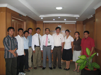
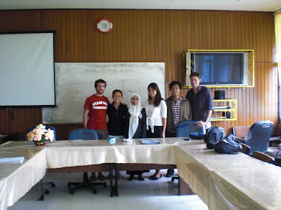
Meeting with President of Andalas University
July 1, 2010
Our very first meeting of the trip was with the President of Andalas University. Considering that we've never had such a meeting with the President of Stanford University, we felt honored that he took time to meet with us. It's great that this project has so much recognition.
After introductions, we talked briefly about the project and talked about the student exchanges that we've had so far. The President expressed interest in having further partnerships with Stanford University. Their students have to spend a semester away in another university (domestically or abroad) as part of their studies.
We also met some of the civil engineering students and faculty. Right now it is exam time at the university so many of the students were busy. We are hoping to meet and work with more of them later in July.
An interesting thing about meetings here: there is always tea, coffee, water, or some sort of drink and maybe a snack. It is customary to serve your guests something to drink. Something to keep in mind in case someone ever wants to meet with us.
Our very first meeting of the trip was with the President of Andalas University. Considering that we've never had such a meeting with the President of Stanford University, we felt honored that he took time to meet with us. It's great that this project has so much recognition.
After introductions, we talked briefly about the project and talked about the student exchanges that we've had so far. The President expressed interest in having further partnerships with Stanford University. Their students have to spend a semester away in another university (domestically or abroad) as part of their studies.
 |
| From Padang Summer 2010 |
We also met some of the civil engineering students and faculty. Right now it is exam time at the university so many of the students were busy. We are hoping to meet and work with more of them later in July.
An interesting thing about meetings here: there is always tea, coffee, water, or some sort of drink and maybe a snack. It is customary to serve your guests something to drink. Something to keep in mind in case someone ever wants to meet with us.
Indonesian Class (with example phrases)
--- written by Greg on 7/14/2010, Jakarta, 11:00pm, 9:00am PST ---
Fengky organized a language class for us at Andalas. It has been incredibly helpful to understand some of the common words and phrases in addition to some of those that we will need when discussing tsunami and earthquake preparedness. The instructor, Ibu (Mrs.) Yetti, is a lively 60 year-old woman who tries not to speak English at all while we are in class. It helps a lot to figure out all of the little articles so we can make sentences rather than a series of words. We are now able to discuss our days with hardly any details, ask what time it is, and understand some of the signs on the streets and foods we see on menus. Additionally, we have learned how the Minang language (spoken by most in Padang) is different from the Indonesian language along with a few key words that we should know. Here is just a little sampling of what we know how to say without a dictionary:
Kami pergi ke pantai Padang untuk minum kelapa muda dan nasi goreng sehari hari.
We go to Padang beach for coconut water and fried rice everyday.
Apa? Kamu makan keju semua? Ada keempat minggu ini!
What? You ate all the cheese? That’s the fourth time this week!
Teman saya suka melihat futbol. Kami tinggal dengan orang dari Amerika, Inggris, Ivory Coast, dan Japang. Selamat datang ke Epcot di Padang, rumah kami.
My friends like to watch soccer. We live with people from the United States, England, Ivory Coast, and Japan. Welcome to the Padang’s Epcot Center, our house.
Kami belajar bagaimana walikota dari kota Padang jalan untuk evakuasi cepat cepat.
We are studying how the people of the city of Padang walk to evacuate quickly.
 |
| From Padang Summer 2010 |
Fengky organized a language class for us at Andalas. It has been incredibly helpful to understand some of the common words and phrases in addition to some of those that we will need when discussing tsunami and earthquake preparedness. The instructor, Ibu (Mrs.) Yetti, is a lively 60 year-old woman who tries not to speak English at all while we are in class. It helps a lot to figure out all of the little articles so we can make sentences rather than a series of words. We are now able to discuss our days with hardly any details, ask what time it is, and understand some of the signs on the streets and foods we see on menus. Additionally, we have learned how the Minang language (spoken by most in Padang) is different from the Indonesian language along with a few key words that we should know. Here is just a little sampling of what we know how to say without a dictionary:
Kami pergi ke pantai Padang untuk minum kelapa muda dan nasi goreng sehari hari.
We go to Padang beach for coconut water and fried rice everyday.
Apa? Kamu makan keju semua? Ada keempat minggu ini!
What? You ate all the cheese? That’s the fourth time this week!
Teman saya suka melihat futbol. Kami tinggal dengan orang dari Amerika, Inggris, Ivory Coast, dan Japang. Selamat datang ke Epcot di Padang, rumah kami.
My friends like to watch soccer. We live with people from the United States, England, Ivory Coast, and Japan. Welcome to the Padang’s Epcot Center, our house.
Kami belajar bagaimana walikota dari kota Padang jalan untuk evakuasi cepat cepat.
We are studying how the people of the city of Padang walk to evacuate quickly.
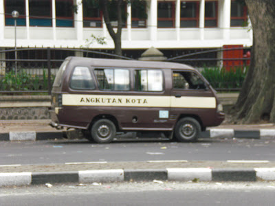
Transportation
--- written by Greg on 7/14/2010, Jakarta, 11:00pm, 9:00am PST ---
Much like many of you probably do, we take public transportation to our meetings, the university, potential TEREP sites, and the Construction Clinic. What might be different is the music you listen to, the people you ride with, the age of the driver, and the color/stickers that are on the vehicle itself. We ride in angkots most of the time, which cost about 20¢ per ride to many places in the city. They are color coded depending on their route, but it does take a long time to understand the twists and turns it takes on its route. There is hip-hop or techno music, some love songs, but always very loud to attract the youth of Padang. We also ride the bigger buses to Andalas (just as colorful and loud), and sometimes take ojeks if it is late or somewhere hard to get to. Never a dull moment in transit (or traffic).
Much like many of you probably do, we take public transportation to our meetings, the university, potential TEREP sites, and the Construction Clinic. What might be different is the music you listen to, the people you ride with, the age of the driver, and the color/stickers that are on the vehicle itself. We ride in angkots most of the time, which cost about 20¢ per ride to many places in the city. They are color coded depending on their route, but it does take a long time to understand the twists and turns it takes on its route. There is hip-hop or techno music, some love songs, but always very loud to attract the youth of Padang. We also ride the bigger buses to Andalas (just as colorful and loud), and sometimes take ojeks if it is late or somewhere hard to get to. Never a dull moment in transit (or traffic).
Thursday, July 22, 2010
Introduction to the Project
--- written by Greg on 7/14/2010, Jakarta, 11:00pm, 9:00am PST ---
It’s hard to believe that we have already been in Padang for more than 2 weeks. It has gone by incredibly fast since we have been keeping so busy every day. We’ll try to give you an idea of what we have been doing daily, with whom we have been meeting, and maybe a little of how life is in Padang.
First, although many of you reading know a good amount about the project, I think a little background as to why we are spending 2 months in Padang, Indonesia would be appropriate. For the past 1 ½ years, GeoHazards International (GHI) and Stanford Engineers for a Sustainable World (ESW) have been working towards tsunami preparedness in Padang. This city is at the highest tsunami risk in the world, and the local government has not worked very hard to prepare its population of nearly 1 million, half of whom live within 1 km from the coast. Stanford ESW held a class in Spring 2009 to learn about the problem and come up with a few different ways to combat it, from vertical evacuation in buildings, to horizontal evacuation capacity in terms of bridges and other infrastructure in addition to more research into the earthquake and tsunami hazard. In the Summer of 2009, Kelly Wood and Scott Henderson from Stanford, and Veronica Cedillos from GHI, spent about 2 months in Padang researching buildings and the general capacity of the city to handle a catastrophic tsunami that is bound to happen in the next 30 years. On September 30, 2009, Padang experienced a M7.6 earthquake that destroyed many buildings in the city and made apparent the problems that the city will have with evacuation if there is in fact a tsunami (luckily it was only 12” rather than 20m).
Building on the research from the summer and that from the class in the Spring, ESW held a seminar in Winter 2010, led by Kelly Wood, that described to the new batch of Stanford ESW students the issues that Padang faces. After Adam Jongeward and I (Greg Rulifson) took a quick 10 day reconnaissance trip over Spring Break 2010 to work with the students at Andalas University (our partner university) and try to understand what is most important to address in the city with the students who were enrolled in the class for Spring 2010 that I led with Adam. We arrived at 4 teams for the 16 students in the class, who all did great work that we are able to use when discussing the potential of the different options (artificial hill - TEREP, retrofit, new building) that exist for vertical evacuation. This is incredibly important for those who cannot evacuate in time horizontally (away from the coast), so they need to be able to seek safety by getting above the flow of water. I will try to post the products that the teams produced by the end of the quarter that we are working with currently in Padang.
This project has been very successful with the support of the John A. Blume Earthquake Engineering Center, Stanford ESW, engineering firms in the Bay Area who have generously offered their expertise and time, and GeoHazards International who has a great interest in working with the students and engaging them in a real problem existing in the world today. Also, the project won a Mondialogo award, which allowed two students from Andalas University (Andi Syukri and Fengky Yoresta) to visit Stanford and San Francisco for three weeks at the end of the Spring quarter. We are very thankful to have been able to strengthen the bond and collaboration between the universities so this summer work is even more productive since we know each other well. And now, on to Summer 2010…
Lucy and I arrived in Padang from Kuala Lumpur on Tuesday, June 29th in the afternoon, greeted by Fengky, one of the Andalas University students who came to Stanford. A short bus ride and a walk brought us to our summer residence: the dorms at Fakultas Kedokteran (medical school). Andalas University has generously allowed us to stay there with other foreigners who are teaching at the university or doing research. They are all great people and a lot of fun to hang out with in the evenings to go to the beach or watch the World Cup games from 1-3am. Our cozy little room has worked out very well so far after a little fixing up to keep the mosquitos out, especially the refreshing bucket showers each day.
Subscribe to:
Posts (Atom)